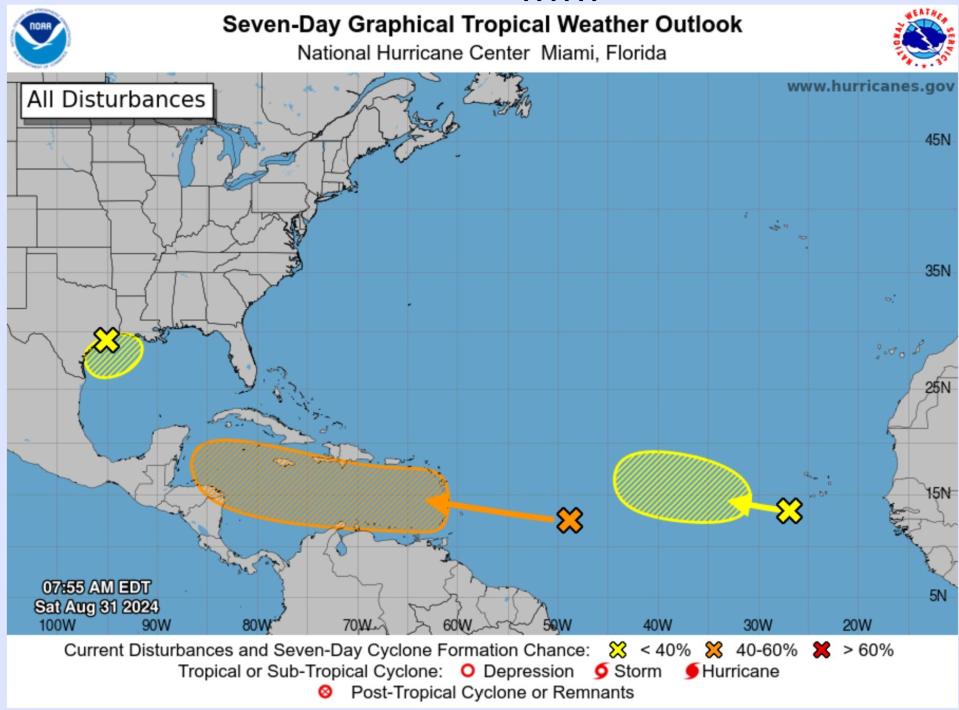
The 2024 hurricane season has been fairly quiet so far, but the National Hurricane Center is tracking three tropical disturbances with low to medium chances of developing after Labor Day weekend.
The three tropical systems could form in the North Atlantic, the Caribbean Sea and the Gulf of Mexico, according to a tropical weather outlook from the National Hurricane Center. They are near the following locations:
-
Northwestern Gulf of Mexico, just offshore of the upper Texas coast
-
Near the Lesser Antilles and Caribbean Sea
-
Eastern Tropical Atlantic Ocean, over western Africa
None of the storms have been named, and there is a less than 45% chance they will develop in the next seven days, according to the National Hurricane Center.
Will there be more hurricanes? After an Atlantic hurricane season pause, are the tropics starting to stir?
Atlantic storm tracker
Storm developing in Gulf of Mexico
The storm off of the Texas coast is expected to move inland on Tuesday, but the storm has not developed into a tropical storm or hurricane.
It’s expected to “meander near the coast for the next couple of days,” according to the National Hurricane Center. It will likely produce thunderstorm activity near the Texas and Louisiana coasts.
If it remains in the water, slow development is possible. Still, regardless of its formation, heavy rain could cause flash flooding across coastal Louisiana and Texas’ upper coast.
There is a 10% chance it will develop in 48 hours, and a 10% chance it will develop in seven days.
Tropical wave by Lesser Antilles, Caribbean Sea
A tropical wave that is several hundred miles away from the Lesser Antilles, an arc of islands in the Caribbean, is expected to move westward and reach the grouping of islands by Monday before crossing the eastern Caribbean Sea on Tuesday.
On Monday, portions of the islands could face “gusty winds” and heavy rainfall, according to the National Hurricane Center.
The storm has a medium chance of developing over the next 7 days. A tropical depression could form later in the week as conditions become “more conducive for development” as the storm moves across the central and western Caribbean Sea.
There is a 10% chance it will develop in 48 hours, and a 40% chance it will develop in seven days.
Eastern Tropical Atlantic Ocean, over western Africa
The storm is expected to move off of Africa’s coast on Monday, according to the National Hurricane Center.
Conditions could allow the storm to slowly develop throughout the week as it creeps westward or west-northwestward across the eastern tropical Atlantic Ocean.
The odds of the storm developing are still low, with a near 0% chance it will develop in 48 hours and a 20% chance it will develop in seven days.
Forecasters tracking multiple tropical waves
The National Hurricane Center is also tracking three tropical waves:
-
A tropical wave in the eastern Atlantic was moving westward.
-
A tropical wave in the central Atlantic was moving westward. Scattered moderate convection were noted.
-
A tropical wave in the western Caribbean and crossing into the Pacific was moving westward. The tropical wave extends across southeastern Mexico through El Salvador and into the eastern Pacific. Scattered showers and isolated thunderstorms are present along the Pacific coast of Central America.
How active is the 2024 hurricane season?
In August, Hurricane Ernesto hit Bermuda and brought life-threatening surf and rip currents to the U.S. along the East Coast.
In July, we saw the earliest Category 5 hurricane when Hurricane Beryl caused “catastrophic damage” and 20 deaths as it slammed into multiple islands in the Caribbean. Hurricane Beryl has a preliminary death toll of 25 from when it entered the U.S. and moved through Texas, Louisiana and Vermont, according to the National Oceanic Atmospheric Administration.
“Atmospheric and oceanic conditions have set the stage for an extremely active hurricane season that could rank among the busiest on record,” according to the NOAA’s website.
In 2024, there could be 17-24 named storms in the Atlantic. Around eight to 13 of them could become hurricanes, while four to seven can become major hurricanes with winds greater than 111 mph.
Usually, there will be around 14 named storms. Seven have become hurricanes, and three have become major hurricanes during the season, which takes place from June 1 through Nov. 30.
This article originally appeared on USA TODAY: Storm tracker: National Hurricane Center tracking 3 storms