Floridians are still recovering from the devastating Hurricane Milton, which made landfall near Siesta Key Wednesday evening and barreled across the state bringing catastrophic damage and widespread flooding, leaving millions without power for days and contributing to at least 17 deaths so far. But there’s a peaceful, cooler few days ahead, according to the National Hurricane Center.
The NHC is tracking three tropical waves, including one in the Atlantic, Invest AL94. that may develop into a tropical depression by the end of the week. For the next few days, poor conditions are expected to keep it from developing as it moves westward to potentially threaten the Leeward Islands.
Meanwhile, a cold front will move into the north Gulf of Mexico late Tuesday night into early Wednesday morning, cooling off much of the state and bringing overnight temps down into the 50s for north Florida this week.
Hurricane Leslie dissipated Saturday in the Atlantic, the NHC said.
If Invest AL94 develops into a tropical storm, the next name of the 2024 Atlantic hurricane season will be Nadine.
➤ Weather alerts via text: Sign up to get updates about current storms and weather events by location
The NHC is tracking:
-
Invest 94L in the Atlantic, with early models showing it heading toward the Leeward islands
-
A tropical wave in the Caribbean south of eastern Hispaniola
-
A tropical wave moving westward in the northwest Caribbean
Spaghetti models for Invest AL94
Special note about spaghetti models: Illustrations include an array of forecast tools and models, and not all are created equal. The Hurricane Center uses only the top four or five highest performing models to help make its forecasts.
Watches and warnings issued for Florida, US
What else is out there and how likely are they to strengthen?
Systems currently being monitored by the National Hurricane Center include:

Invest 94L, in the southwestern Atlantic: A well-defined area of low pressure located several hundred miles west of the Cabo Verde Islands is producing minimal showers and thunderstorms. This system is currently embedded in an unfavorable environment and development is not anticipated over the next couple of days. However, this system is forecast to move generally westward to west-southwestward, and environmental conditions could become more favorable for gradual development by the middle to latter part of this week.
A tropical depression could form as the system begins moving west-northwestward and approaches or moves near the Leeward Islands by the end of this week.
-
Formation chance through 48 hours: low, near 10 percent.
-
Formation chance through 7 days: medium, near 40 percent.
What do the colored areas on the NHC map mean?
The hatched areas on a tropical outlook map indicate “areas where a tropical cyclone — which could be a tropical depression, tropical storm or hurricane — could develop,” said National Hurricane Center Deputy Director Jamie Rhome.
The colors make it visibly clear how likely a system could develop with yellow being low, orange medium and red high.
The National Hurricane Center generally doesn’t issue tropical advisories until there is a named storm, but there is an exception.
“If a system is near land and there is potential for development, the National Hurricane Center won’t wait before it issues advisories, even if the system hasn’t become an actual storm. This gives residents time to prepare,” Rhome said.
Excessive rainfall forecast
Interactive map: Hurricanes, tropical storms that have passed near your city
When is hurricane season over?
The Atlantic hurricane season runs from June 1 through Nov. 30.
The Atlantic basin includes the northern Atlantic Ocean, Caribbean Sea and Gulf of Mexico.
When is the peak of hurricane season?
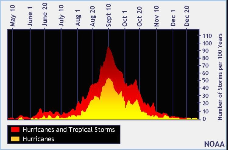
The peak of the season was Sept. 10, with the most activity happening between mid-August and mid-October, according to the Hurricane Center.
What’s next?
We will continue to update our tropical weather coverage daily. Download your local site’s app to ensure you’re always connected to the news. And look for our special subscription offers here.
This article originally appeared on The Daytona Beach News-Journal: NHC tracking 3 tropical waves in Atlantic, Caribbean