The National Hurricane Center is tracking three systems in the Atlantic basin as the remnants of Francine make their way farther north.
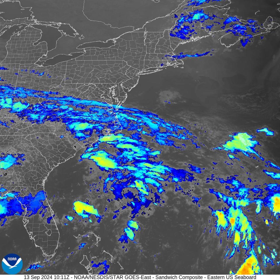
Those remnants from what is now Post-Tropical Cyclone Francine are bringing heavy rain and the risk for flash floods to portions of the Tennessee Valley and the Southeast this morning.
Francine made landfall Wednesday night as a Category 2 storm in Terrebonne Parish in Louisiana with maximum sustained winds near 100 mph.
➤ Weather alerts via text: Sign up to get updates about current storms and weather events by location
Elsewhere in the Atlantic basin, forecasters are tracking:
-
Tropical Depression Seven in the eastern Atlantic
-
Invest 94L near the northern Leeward Islands
-
Disturbance a few hundred miles off Florida and the southeastern U.S.
Here’s the latest update from the NHC as of 2 a.m. EDT Sept. 13:
Tropical Depression 7 could become Tropical Storm Gordon today

-
Location: 955 miles west-northwest of Cabo Verde Islands
-
Maximum sustained winds: 35 mph
-
Movement: west-northwest at 14 mph
-
Pressure: 1007 mb
What you should know about Tropical Depression 7

At 5 a.m. AST, the center of Tropical Depression Seven was located near latitude 19.0 North, longitude 38.2 West.
The depression is moving toward the west-northwest near 14 mph. A turn toward the west is forecast by tonight, with the system gradually slowing down through the weekend.
➤ Spaghetti models for Tropical Depression 7
Maximum sustained winds are near 35 mph, with higher gusts.
The depression could become a tropical storm later today, however little change in strength overall is anticipated through the weekend.
Spaghetti models for Tropical Depression Seven
Special note about spaghetti models: Spaghetti model illustrations include an array of forecast tools and models, and not all are created equal. The Hurricane Center uses only the top four or five highest performing models to help make its forecasts.
Will Tropical Depression 7 impact Florida, US?
Tropical Depression Seven is expected to become Tropical Storm Gordon today but don’t expect any impacts from the system in the U.S., according to Alex DaSilva, AccuWeather lead hurricane forecaster.
“This will not bother anyone, except maybe shipping,” DaSilva said in a telephone interview Thursday. “It will stay in the Atlantic and pose no threat to the U.S.
What else is out there and how likely are they to strengthen?

Offshore the Southeastern U.S. over the western Atlantic: A non-tropical area of low pressure could form along a frontal boundary a few hundred miles off the southeastern U.S. coastline this weekend.
Thereafter, some subtropical or tropical development is possible during the early part of next week while the systemmoves generally northwestward toward the coast.
-
Formation chance through 48 hours: low, near 0 percent.
-
Formation chance through 7 days: low, 30 percent.
Invest 94L, east of the Leeward Islands: Satellite-derived wind data from several hours ago indicate thata small area of low pressure located less than one hundred miles east of the northern Leeward Islands has degenerated into a surface trough.
Environmental conditions, including the proximity of dry air, do not favor development of this system while it moveswest-northwestward at about 15 mph. Regardless of development, locally heavy rainfall and gusty winds are possible across the northern Leeward Islands today.
-
Formation chance through 48 hours: low, 20 percent.
-
Formation chance through 7 days: low, 20 percent.
Could the system northeast of Florida affect your weekend?
While the system off the Southeast U.S. coast may get a boost from what’s left of Francine, don’t expect any direct impacts to Florida over the weekend or early next week.
The system does have the potential to become a named storm. The earliest something could develop would be Sunday and then it would move inland Monday night or Tuesday.
“There may be some increased wave action and rough surf and rip currents, especially in North Florida, but nothing direct,” DaSilva said.
What about Polk County?
Expect fairly normal patterns of afternoon and evening storms Friday and Saturday with decreasing chances of rain Sunday and Monday. Here’s the forecast through Monday from the National Weather Service in Tampa.
Friday: Scattered showers and thunderstorms, mainly after noon. Partly sunny, with a high near 90. Heat index values as high as 103. Calm wind becoming west northwest around 6 mph in the afternoon. Chance of precipitation is 40%.
Friday night: Scattered showers and thunderstorms, mainly before 9 p.m. Mostly cloudy, then gradually becoming mostly clear, with a low around 75. North wind around 5 mph becoming calm in the evening. Chance of precipitation is 30%.
Saturday: Showers and thunderstorms likely, mainly after 2 p.m. Mostly sunny, with a high near 92. Heat index values as high as 102. Calm wind becoming west northwest around 6 mph in the afternoon. Chance of precipitation is 70%. New rainfall amounts between a quarter and half of an inch possible.
Saturday Night: Showers and thunderstorms likely before 8 p.m. Partly cloudy, with a low around 74. North wind around 5 mph becoming calm in the evening. Chance of precipitation is 60%.
Sunday: Scattered showers and thunderstorms after 2 p.m. Partly sunny, with a high near 91. Calm wind becoming northwest around 5 mph in the afternoon. Chance of precipitation is 40%.
Sunday Night: Scattered showers and thunderstorms before 8 p.m. Mostly cloudy, with a low around 74. North wind around 5 mph becoming calm in the evening. Chance of precipitation is 30%.
Monday: Scattered showers and thunderstorms after 2 p.m. Partly sunny, with a high near 90. Calm wind becoming west around 6 mph in the afternoon. Chance of precipitation is 40%.
Monday Night: Scattered showers and thunderstorms, mainly before 8 p.m. Partly cloudy, with a low around 73. West northwest wind around 5 mph becoming calm in the evening. Chance of precipitation is 30%.
And Polk County’s rivers?
Conditions are largely unchanged since Thursday. The NWS has “action” alerts in place on the Hillsborough, Alafia and Peace rivers outside of Polk County, but not inside Polk’s borders.
The Peace River rose barely a couple inches since Thursday morning, measuring 6.87 feet on Friday morning. That’s more than a foot below “minor” flood stage.
The Hillsborough River near Zephyrhills, where Polk’s Blackwater and Itchepackessasa creeks flow into it, fell by a couple of inches from Thursday morning to Friday morning, according to the NWS.
What do the colored areas on the NOAA map mean?
The hatched areas on a tropical outlook map indicate “areas where a tropical cyclone — which could be a tropical depression, tropical storm or hurricane — could develop,” said National Hurricane Center Deputy Director Jamie Rhome.
The colors make it visibly clear how likely a system could develop with yellow being low, orange medium and red high.
The National Hurricane Center generally doesn’t issue tropical advisories until there is a named storm, but there is an exception.
“If a system is near land and there is potential for development, the National Hurricane Center won’t wait before it issues advisories, even if the system hasn’t become an actual storm. This gives residents time to prepare,” Rhome said.
What is an invest?
Short for investigation, the National Hurricane Center uses the term invest for areas of low pressure it is monitoring for potential development into a tropical depression or storm.
Invests are not tropical depressions or tropical storms. They’re usually clusters of showers and thunderstorms, and just because they’ve been designated as an invest does not guarantee they’ll develop into a tropical cyclone.
Invests run from 90 to 99, followed by a letter: L for the Atlantic basin and E for those in the eastern Pacific. After 99, it starts over again and the next invest would be 90.
Once something has been designated as an invest, specialized data sets and computer models can begin, including scheduling Hurricane Hunter aircraft missions and the running spaghetti models.
Who is likely to be impacted?
While Tropical Depression 7 is not expected to impact Florida or the U.S., the system off the southeastern coast could bring some rough surf and rip currents to North Florida early next week, DaSilva said.
Direct impacts are expected for northern South Carolina and North Carolina Sunday through Tuesday, Possible impacts include: Coastal flooding and erosion, 2 to 4 inches of rain and 40-50 mph winds along coastal areas.
It’s too early at this time to determine if there will be any impact to Florida or the U.S. from Invest 94L.
Forecasters urge all residents to continue monitoring the tropics and to always be prepared. That advice is particularly important for what is expected to be a very active hurricane season.
Weather watches and warnings issued in Florida
When is the Atlantic hurricane season?
The Atlantic hurricane season runs from June 1 through Nov. 30.
The Atlantic basin includes the northern Atlantic Ocean, Caribbean Sea and Gulf of Mexico.
Stay informed. Get weather alerts via text
When is the peak of hurricane season?
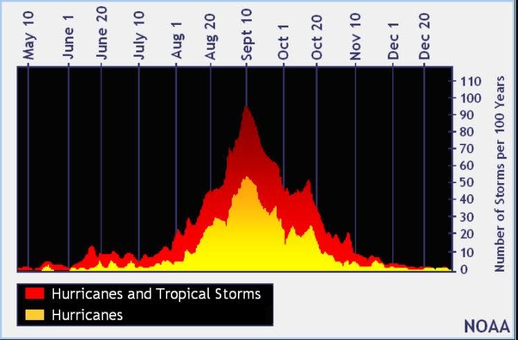
The peak of the season is Sept. 10, with the most activity happening between mid-August and mid-October, according to the Hurricane Center.
National Hurricane Center map: What are forecasters watching now?
Systems currently being monitored by the National Hurricane Center include:
Interactive map: Hurricanes, tropical storms that have passed near your city
Excessive rainfall forecast
What’s next?
We will continue to update our tropical weather coverage daily. Download your local site’s app to ensure you’re always connected to the news. And look for our special subscription offers here.
This article originally appeared on The Ledger: Tropical Depression 7, Invest 94L, system SE coast. Tropical update