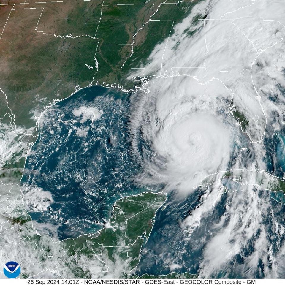
Hurricane Helene strengthened to a Category 2 storm Thursday is quickly barreling down on Florida’s Gulf Coast, growing more powerful as officials warn of likely devastation.
A Thursday forecast from the National Hurricane Center shows the hurricane approaching landfall Thursday night as a Category 3 with winds near 115 mph. AccuWeather forecasters were predicting Helene would reach Category 4 strength − winds of 131 to 155 mph −in the Gulf and maintain that intensity through landfall.
“Helene will quickly become a very large and dangerous hurricane, and it will grow as it approaches the Gulf coast,” AccuWeather Lead Hurricane Expert Alex DaSilva added in a written statement. “Helene is moving over extremely warm waters and will intensify rapidly.”
Here’s what to know about the storm.
What is the track of Hurricane Helene?
Where is Florida’s Gulf Coast? Where is Florida’s Big Bend?
Helene is predicted to hit Florida’s Big Bend area, an informal name for the area region of Florida where the Panhandle bends into the peninsula that makes up the rest of the state. It covers Jefferson, Taylor, Dixie and Levy counties, and is the northeast corner of the Gulf of Mexico.
Hurricane Helene spaghetti models
Illustrations include an array of forecast tools and models, and not all are created equal. The hurricane center uses only the top four or five highest performing models to help make its forecasts.
Will Hurricane Helene impact Massachusetts?
If you’re worried about the effects of Hurricane Helene reaching the Bay State, you can rest easy. National Weather Service in Norton, Massachusetts noted the storm won’t have any bearing on Massachusetts, or the rest of New England.
Meteorologist Candice Hrencecin of the Norton office noted the storm “is going to sit in the southeast U.S. for a while,” with Georgia seeing any potential leftover remnants of the hurricane.
“Based on the current models, I don’t think rip currents will be a problem in Massachusetts later in the week,” Hrencecin added.
What are the current expectations for Hurricane Helene?
Hurricane Helene is expected to be devastating, with destructive winds and storm surge expected to cause major damage. Meteorologists are also warning of “spin-up” tornadoes caused by the storm that could impact Florida, Georgia and Alabama later on Thursday. On Friday, those tornadoes could show up in the Carolinas, southern Virginia, eastern Tennessee and southeastern Kentucky.
Helene is also expected to bring in devastating storm surge, which is the a surge in sea level caused by a storm that has the ability to wipe out coastal communities. The “catastrophic and deadly storm surge” could reach 15 to 20 feet above ground somewhere along the coast, the National Hurricane Center warned Wednesday.
Warnings ranging as high as 12 feet are in effect elsewhere along almost the entire west coast of Florida, said Jamie Rhome, the center’s deputy director.
“The large size of this storm is going to push so much water,” Rhome said. “When it comes to storm surge the size of the hurricane is more important than the intensity of the storm, which is hard for some people to digest.”

How are hurricanes measured?
You’ve probably heard hurricanes referred to by categories, a metric for ranking how strong they are. According to the National Weather Service, here’s how they work:
-
Category 1: Winds of 74-95 mph, causing minimal damage like flooding and uprooted trees.
-
Category 2: Winds of 96-110 mph, causing moderate damage like coastal flooding, water and electricity shortages, and uprooted trees and signs.
-
Category 3: Winds of 111-129 mph, causing extensive damage.
-
Category 4: Winds of 130-156 mph, causing catastrophic damage like loss of roof structure and exterior walls, downed power poles and uprooted trees.
-
Category 5: Winds of 157 mph or higher, the worst-case scenario, causing devastating damage.
Projections currently put Helene as a Category 3 or Category 4 storm when it makes landfall.
What was the last hurricane to hit the southern states?
Hurricane Ernesto hit the southern states of the U.S. about two weeks ago. It was a Category 1 storm.
What are the overall predictions for this hurricane season?
At the start of the season, AccuWeather meteorologists predicted more than 20 storms forming in the Atlantic, predicting six to 10 named storms from Aug. 27 through Sept. 30 alone, labeling the month a “supercharged September.”
But that forecast was changed at the end of August.
Initially, AccuWeather meteorologists were predicting 20-25 hurricanes in total for the 2024 season. But in a release on Aug. 29, AccuWeather changed the overall forecast to 20-23 hurricanes, two less than originally predicted.
“The reason for this assessment is the long lull that has been experienced in recent weeks where there have been no named storms during what is typically a very active time of the hurricane season,” AccuWeather Chief Meteorologist Jon Porter said in a written statement at the end of August.


How many hurricane are typical for this time of year?
The record number of named storms in the Atlantic basin from Sept. 1 through the end of the season is 16, according to AccuWeather. Meteorologists there say there have been seasons in the past where eight named storms formed in the month of October, and three named storms formed in November.
For the same time period of Aug. 27 to Sept. 30, the historical average is six named storms, according to AccuWeather.
How long does hurricane season last?
The season runs from June 1 to Nov. 30 in Massachusetts and the rest of New England.
USA Today contributed to this report.
This article originally appeared on wickedlocal.com: Hurricane Helene Tracker: Map, when it will hit Florida, projected path
