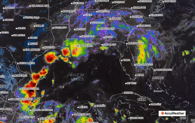
The lull in the Atlantic appears to be quite over as four tropical disturbances are scattered throughout the Atlantic, Caribbean Sea and Gulf of Mexico, including a tropical rainstorm that is expected to drench Texas and Florida into this weekend.
The National Hurricane Center is tracking Invest 90L, which is expected to bring six to 10 inches of rain across Florida’s coastal Panhandle and western Big Bend area through the weekend. Some areas could see more than a foot of rain, according to the Florida Department of Emergency management.
There are three other tropical waves the NHC is tracking, all of which have a low chance of development.
Tropical rainstorm expected to drench Florida Panhandle could become tropical depression or storm
The Florida Panhandle is looking at cooler temperature this weekend, with high temperatures dipping as low as 73 degrees on Saturday before rising to a nice 78 and 81 degrees on Sunday and Monday, respectively.
That is, unfortunately, where the good news ends as AccuWeather predicts that the tropical rainstorm, which already dumped heavy rains on Texas over Labor Day weekend, could develop into a tropical depression or a weak tropical storm.
AccuWeather warns of the risk of waterspouts and tornadoes from locally severe thunderstorms that could occur along the Gulf Coast.
Four to eight inches of rain predicted for Florida Panhandle
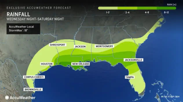
AccuWeather is predicting that the Pensacola area will be among the biggest impacted, with the possibility of major urban flooding. There are pockets of areas along the Gulf Coast that are expected to receive eight to 12 inches of rain. Pensacola rests in a band where rainfall estimates are between four and eight inches.
Tropical tracker: Spaghetti models, what you need to know about Invest 90L
Special note about spaghetti models: Spaghetti model illustrations include an array of forecast tools and models, and not all are created equal. The Hurricane Center uses only the top four or five highest performing models to help make its forecasts.
Invest 90L: Showers and thunderstorms associated with a low pressure system and weak frontal boundary over the northwestern Gulf of Mexico remain disorganized.
➤ Spaghetti models for Invest 90L
Upper-level winds are expected to remain unfavorable for significant development of this system while it meanders over the northwestern Gulf and eventually merges with another approaching frontal system later today or on Saturday.
Although tropical cyclone development is unlikely, heavy rainfall is expected to continue across portions of the northern Gulf Coast during the next day or so
-
Formation chance through 48 hours: low, 10 percent.
-
Formation chance through 7 days: low, 10 percent.
What else is out there and how likely are they to strengthen?
Eastern Tropical Atlantic: An elongated trough of low pressure over the eastern tropical Atlantic is producing minimal shower and thunderstorm activity.
Development, if any, should be slow to occur while the disturbance meanders through the early part of next week and then begins to move west-northwestward across the central tropical Atlantic during the middle to latter part of next week.
-
Formation chance through 48 hours: near 0 percent.
-
Formation chance through seven days: low, 10 percent.
Northwestern Caribbean Sea and Southwestern Gulf of Mexico: A tropical wave located near the coast of Belize and the Yucatan Peninsula of Mexico continues to produce disorganized showers and thunderstorms.
The wave is forecast to move across Central America and southeastern Mexico today and tonight, and some slow development is possible over the weekend after the system emerges over the southwestern Gulf of Mexico.
-
Formation chance through 48 hours: near 0 percent.
-
Formation chance through 7 days: low, 20 percent.
Invest 99L: Satellite images indicate that a gale-force low pressure system located several hundred miles east of the U.S. Mid-Atlantic coast is producing a large area of showers and thunderstorms that are increasingly taking on a non-tropical structure.
➤ Spaghetti models for Invest 99L
The low is forecast to move north-northeastward at 15 to 20 mph offshore the northeastern United States, reaching colder waters by this evening and overnight, and its opportunity to acquire subtropical characteristics appears to be decreasing.
-
Formation chance through 48 hours: low, 20 percent.
-
Formation chance through 7 days: low, 20 percent.
This article originally appeared on Pensacola News Journal: AccuWeather: Invest 90L to bring 4-8 inches rain to Florida Panhandle